There is so much you can do in the Pacific Northwest. Five days is not going to even come close to allowing you enough time to cover it all. However, in this blog, I've selected five spots to get to after landing in Portland, Oregon and you can see it all in 5 days - if you're up for doing some driving that is!
Samuel H Boardman State Scenic Area
Where is it?


Out of these five locations, this one is the furthest away from Portland on the southern Oregon coast (right around 6 hours driving). It is also the area that I have explored the least. From what I have seen though, it is the most beautiful and rugged 12 mile section the Oregon Coast has to offer. Named for the Oregon Parks first superintendent, this stretch of coastline is lined with steep cliffs, sea stacks, forest area, and small sand beaches here and there.
The crown jewel of the Scenic Corridor is the Natural Bridges area, where I set up shop for a beautiful sunset. There are trails branching down from both sides of the parking area. As you can see below, you are able to get down to stand on top of the natural bridges. It is somewhat treacherous, so extreme caution must be used. The iconic view seen below can be found taking the trail down on the north side of the parking area. The next time I come here, I think I'll be spending a couple of nights to take it all in and get in some more hiking!
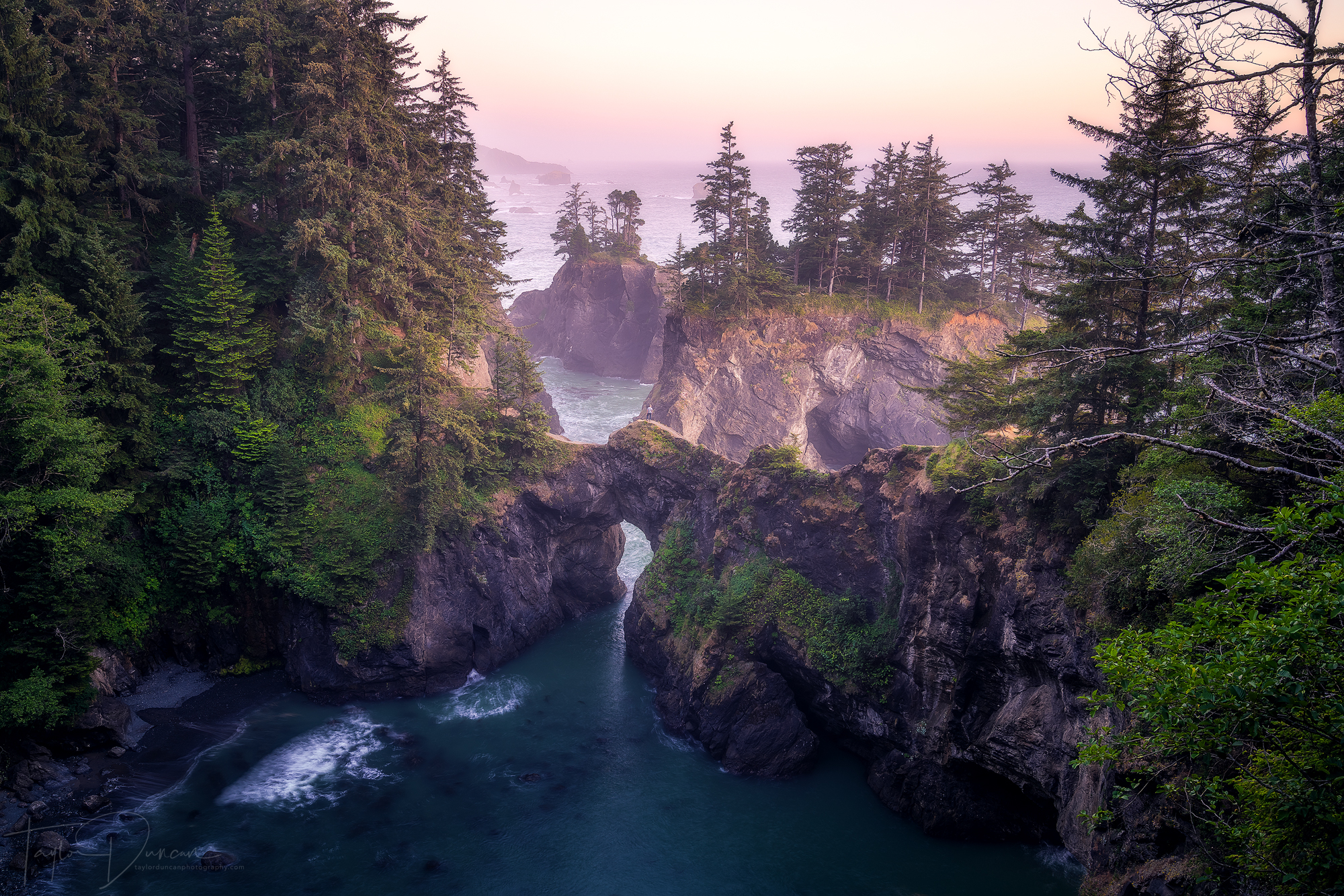
@johndelone stands on top of one of the natural bridges along the Samuel H Boardman Scenic Corridor
Sparks Lake
Where is it?

Sparks Lake is one of the most beautiful lakes in Oregon and the most beautiful along the Cascade Lakes highway in my opinion. If you're following along with the 5 day trip, Sparks Lake is another long drive - 5hrs 45mins from Natural Bridges. It's an easier 3hr 45min drive from Portland or just a quick 40 minute drive from Bend!

This is one of the best sunsets I've ever seen the night before the 2017 Solar Eclipse
This is such an iconic location in Oregon. Named for a Central Oregon stockman, "Lige" Sparks, the lake has incredible views to the north of South Sister (10,358ft), Broken Top (9,175ft), and Mt. Bachelor (9,068ft) to the south.
There is a hiking trail on the south side of the lake offering the views pictured. The top activities to do include stand up paddle boarding or kayaking the lake for some water exploration. The lake only has a maximum depth of 10 feet, so be sure not to ground yourself!

A kayaker paddles across Sparks Lake under a dramatic sky - he was the first of about 10 paddlers I saw!
Proxy Falls
Where is it?

The drive to Proxy Falls is breathtaking no matter which direction you come from. The most scenic drive is out of Bend taking around 1hr 40mins. After turning onto Hwy 242 out of Sisters, you'll be treated to a winding road through a massive lava field with views of five Oregon mountain peaks. Then just like that, you'll find yourself in a dense mountain forest before coming to the trailhead shortly after.

Hike up to the right side of the falls for a chance to see a rainbow!
The day use fee is $5, but I think I'd definitely pay more to see this place. The trail is a 1.5 mile loop through beautiful forest and a small lava field with off-shoot trails leading to Upper and Lower Proxy Falls. They are both beautiful in their own respects, but Upper Proxy is much more rewarding to see as it is completely visible! While hiking through the woods, you start to hear the power of the falls, but you can only appreciate it once you round the last bend and find the viewing area of the 226 foot split falls. It is a sight to see.
For those of you feeling adventurous, the trail does continue down a steep incline where you can clamber over rocks and logs (being careful not to slip) to get to the base of the falls. That's where you feel the real power of the water getting soaked in minutes if a breeze is headed in the right direction. Be sure to find a log to sit on to just take it all in for a few moments!

@heytaynels takes a stroll along the iconic log in front of the falls
Koosah & Sahalie Falls
Where are they?

Sahalie & Koosah Falls are very close to Proxy Falls - only about a half hour driving west on Hwy 242 then north on Hwy 126. I would recommend doing all three in a day! Sahalie and Koosah themselves are only about a mile apart and there is a trail connecting the two following the deep turquoise and blue McKenzie River. If you're lazy like me, each waterfall does have it's own parking area!

Sahalie Falls as seen from along the river trail
Sahalie Falls has many viewpoints. The first is from just in front and to the side of the falls, but if you take the trail just outside of the parking area, you'll find a viewpoint from the top of the falls. If you're up for some exploring, you can continue up this trail for amazing views of the McKenzie River. There is also a bridge to take you to the trail on the other side of the river giving you yet another perspective.

@annadouangphachanh takes in the power of Koosah Falls
Both are powerful waterfalls in their own respects, but Koosah Falls is a force! The water flows off the cliff 70 feet down at an immense rate. Depending on the water levels, the waterfall can be one continuous falls or broken up into a few different shoots. The official viewing area doesn't give you a great view of the falls. You have to look through many branches and lean out over the railing in the corner of the area to get the full view. If you're feeling adventurous, there's a small narrow / steep path down to the base of the falls where you can feel the force of the falls. Be extremely careful on the path as it is wet and slippery!
In Chinook Jargon, Sahalie translates to "Heaven" and Koosah translates to "Sky" - I can see why.
Gifford Pinchot National Forest
Where is it?

The Gifford Pinchot National Forest encompasses 1,368,300 acres in southern Washington protecting mountain forests, valleys, lakes, and beautiful waterfalls. It is another area that I'd like to explore more, but I'm going to tell you about two of its many waterfalls - Falls Creek Falls and Panther Creek Falls. Each one is about 1hr 40mins from Portland and only about 30 minutes apart from each other.

Falls Creek Falls from the creek level

@annadouangphachanh takes in Falls Creek Falls from the viewpoint
Falls Creek Falls is a gigantic 3 tiered waterfall accessed from the Falls Creek Trail on Forest Road 53 just north of Carson, Washington. The entire time we were there, my girlfriend kept saying that it would be incredible to get a clear view of all three at once. Unfortunately theres a very small window on the 5 mile roundtrip trail where you get a limited view of all three. Once to the viewing area, you get a view of the lower tier and middle cascade surrounded by forest. A small trail leads you down to a closer view of the falls.
There is also a trail just before the viewpoint down to the right that takes you down to creek level - it is definitely only for those who are very sure footed and ready for an extra challenge. Once you reach the creek, you'll get a perspective (as seen above) from just down the creek and it is stunning!

Panther Creek Falls surrounded by greenery
Panther Creek Falls is only 8 miles away from the Falls Creek trail on Forest Road 65 - the drive takes roughly 30 minutes. There is a small sign for the trailhead, but you'll recognize a large area off the side of the road for parking. The trail is on the south side of the off-road area and leads steeply down about a quarter mile to a viewing area of this impressive waterfall. If you're up for some serious adventure, find the trail just above the viewpoint and it will take you down to the base of the falls and also Lower Panther Creek Falls. This is an extremely treacherous trail though and must be done with caution. Once down, you can walk right up to the base of the falls and get a new perspective on one of the most unique waterfalls I've ever seen!

Panther Creek Falls as seen from the lower falls
Thank you so much for reading through this blog! I'd also like to shoutout some people who helped make my June 2018 trip to Oregon incredible - Johnny (@johndelone), Michael (@michaelschubert), Tomas (@photomas), Max (@maxrhulen), Levi (@levi_kramer), Taylor (@heytaynels), my mom Lisa, and of course my girlfriend Anna (@annadouangphachanh).
Also, congratulations on your marriage Mike & Brittany!!
