
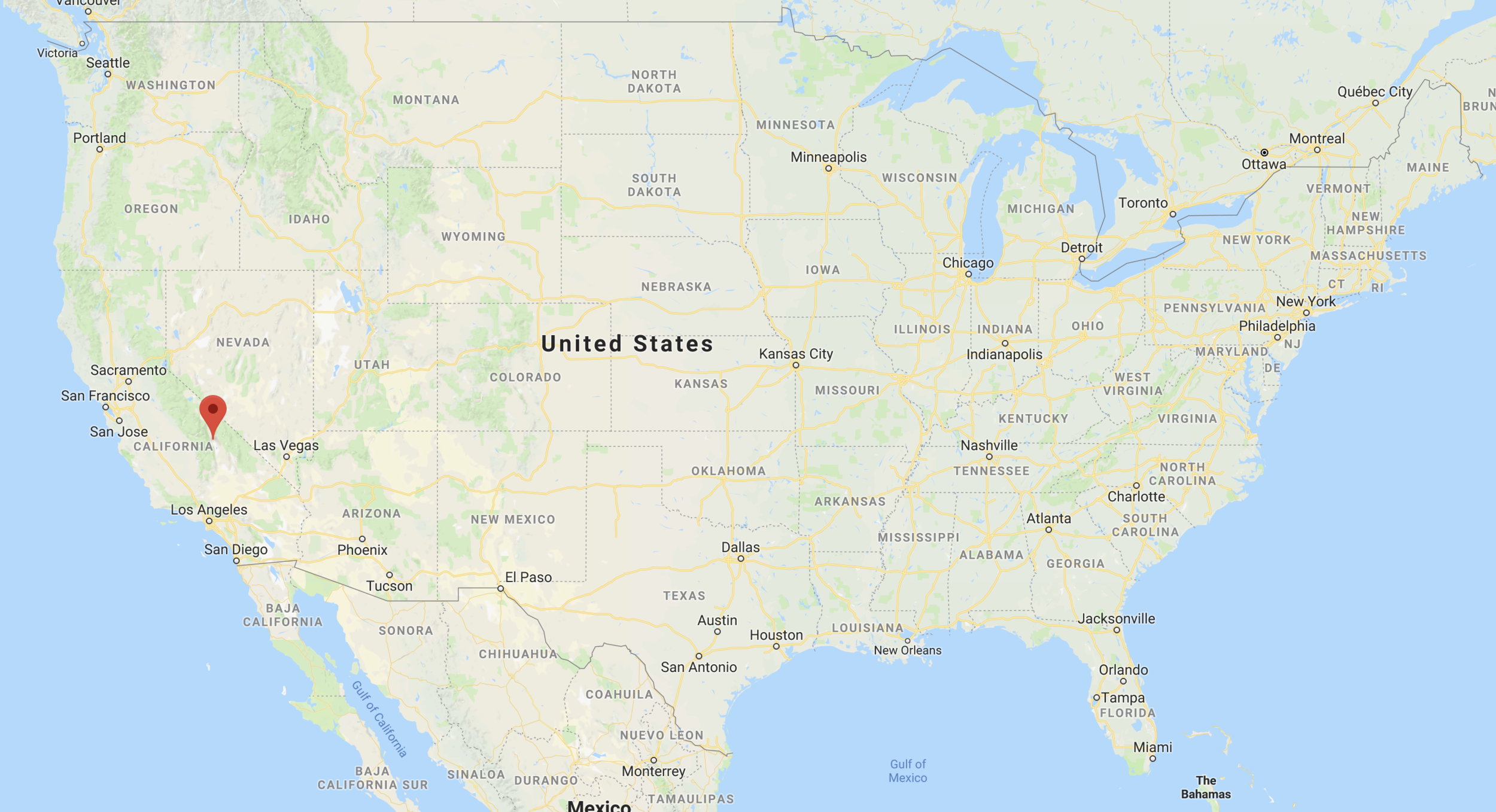
In April of 2018, I packed up my Subaru Outback after a Wisconsin snowstorm and embarked on what would end up to be a 5,100 mile road trip through the much warmer Southwest USA. In my first blog post, I would like to share the story of my trip and hopefully give you ideas on where to go on your next adventure!
Itinerary

Day 1: Drove to Wichita, Kansas - boring 11.5 hour drive.
Day 2: Drove to Alamogordo, New Mexico - mostly boring 11.5 hour drive. Stayed the night in Alamogordo.
Day 3: White Sands National Monument - Met up with new friends and hiked around Alkali Flats trail. Found campsite before sunset, ate Mountain House dinner, and photographed the display in the dunes in the Southwest sunset.
Day 4: White Sands National Monument & Shiprock - Woke up for Milky Way shoot in the early AM and stayed up for sunrise. Hiked back to the car and drove six hours to Shiprock, New Mexico for the sunset and evening stars. Stayed in Farmington, New Mexico for the night. Shiprock is on Navajo land, and it is illegal to camp around it. People do, but for us it was better safe than sorry.
Day 5: Alabama Hills - Woke up early and drove 12 hours solo to Lone Pine, California and found a campsite in the Alabama Hills before photographing the sunset and stars above Mt. Whitney & Lone Pine Peak.
Day 6: Alabama Hills & Death Valley National Park - Woke up for a sunrise hike to Mobius Arch then drove 1.5 hours to Death Valley National Park. The temperature was around 102 degrees, so I decided to get a room at the Stovepipe Wells Hotel. It was nice, because the hotel was five minutes from the parking lot to the Mesquite Flat Sand Dunes, where I hiked in and photographed the sunset.
Day 7: Escalante Day Zero - Woke up early to pick up a friend in Las Vegas, Nevada and drove to Escalante, Utah through Zion National Park, which was a treat! We opted to stay in the Canyons Bed & Breakfast - I would HIGHLY recommend it!
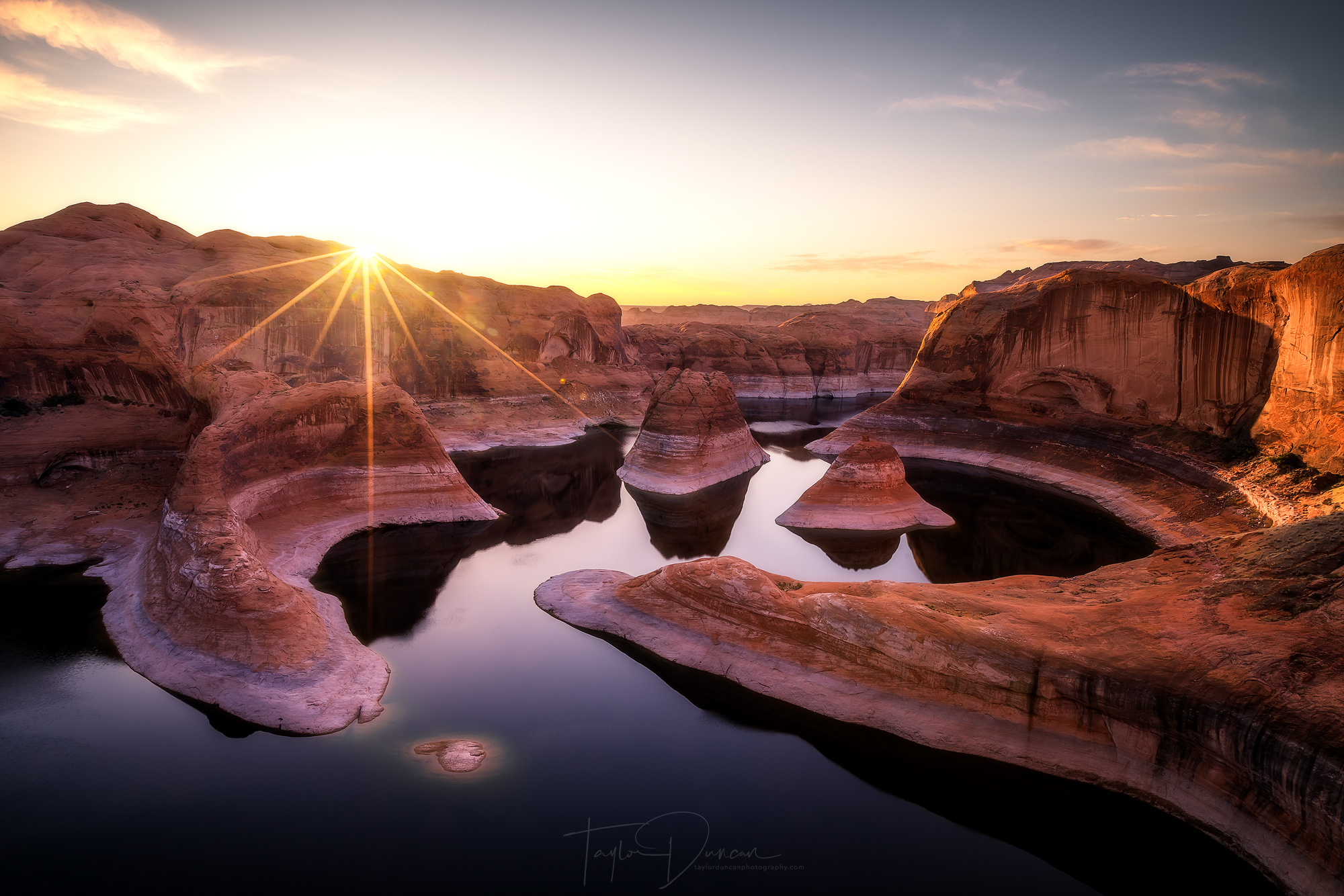
Day 8: Escalante Day One - Drove 60 miles down Hole-In-The-Rock Road to Reflection Canyon Trailhead and photographed dusk and the sunset during our 8.5 miles to Reflection Canyon.
Day 9: Escalante Day Two - Photographed the sunrise. Hiked 8.5 miles back to the car and drove to Zebra Slot Canyon for a 5.5 mile round trip hike. Drove 30 miles back down road to Crack-In-The-Wall trailhead to camp for the night and meet up with more friends.
Day 10: Escalante Day Three - Hiked 10 miles to Jacob Hamblin Arch in Coyote Gulch via Crack-In-The-Wall and camped for the night.
Day 11: Escalante Day Four - Hiked two miles out of Coyote Gulch, back to the car, and drove to Denver, Colorado for the night.
Day 12: Drove home: 15 hours through 30-40mph crosswinds in Nebraska and Iowa to Milwaukee, Wisconsin.
White Sands National Monument, New Mexico
Where is it?

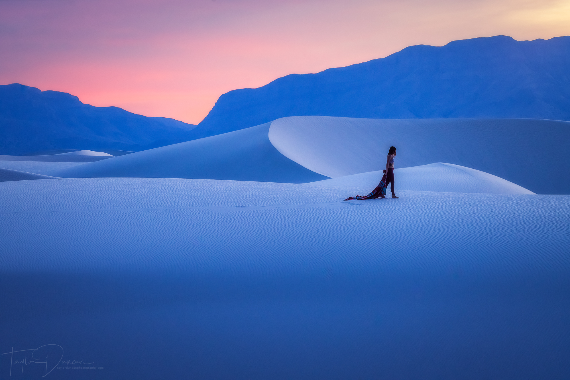
@dani_the_explorer takes a stroll across the white sand with the San Andres Mountains in the background
The Story
I finally got to White Sands National Monument after two full days of driving. There is nothing special about driving across the plains, so I was ready for a break from the endless flat countryside! Even the drive up to the dunes was nothing special, but once I got to the visitors' center, I knew I was in for a treat.

I was supposed to meet @dani_the_explorer, @scottyreichard, and @spencerfochtman for some dune exploration, but there wasn't quite a concrete plan yet. Until they got to the dunes, I decided not to venture too far in and did some shorter, touristy hikes remaining in cell service. These were a nice taste for what we would later find. I was able to get a fuller dune experience reading all of the information signs they had and spotted some of the dune wildlife that has adapted incredibly well to the white sand. Find the white lizard and please excuse the quality of the super zoomed in phone photo!
Around noon, I met the three Instagrammers for the first time, and we ventured further into the dunes to the Alkali Flats trail - a five mile loop at the heart of the dunes. There are markers for the trail, but we wandered around aimlessly making jokes, laughing, and taking photos as we went.
Both @spencerfochtman and I had both been to Great Sand Dunes National Park, Colorado, and we kept trying to compare the two dune fields. It was hard not to. The beauty from the Great Sand Dunes came from their vastness and enormity. The White Sands however are much different. They are not as large and do not cover as much geographical area, but look pure because they are perfectly white.
Notice the changed color of the dunes as the sunset fades
Our day continued on to a campsite in the backcountry camping area - Campsite 2. This site offered perfect access to the dune field for sunset. After dinner, we hiked through the dunes. They changed color while the sun started to set. I thought the Great Sand Dunes were beautiful at sunset, but these dunes mirrored the colors of the sky perfectly. They turned a golden yellow at the start of the sunset and then changed to red then purple and lastly blue before the darkness took over. It was an experience that I won't soon forget, and I'm sure none of my companions will either!
As the night came, our shenanigans continued into the campsite, creating memories with lots of inside jokes. We researched the position of the Milky Way for that night and found that it would be visible at 4;30 am, when the moon went away. We set our alarms for four and called it a night.
The stars were so bright!
@spencerfochtman, @scottyreichard, and I woke ready to go, but @dani_the_explorer remained in her tent needing that extra beauty sleep! She definitely missed out! The Milky Way was almost vertical in the southern sky. As our eyes adjusted while while we moved a tent for photo purposes. The stars seemed to get brighter and brighter! We planned some shots and experimented with flashlights for the majority of the time and got some incredible photos! The light in the clouds in these two photos is light pollution from Las Cruces, NM and El Paso, TX. I'm usually not a fan of light pollution, but in this case it adds another element to the photos that I think really works!
@spencerfochtman had one bright flashlight
As dawn and the sunrise approached, the sands started to change their color again and we were treated to an incredible light display in the sky! I've come to find that I've been pretty spoiled when I've been in the Southwest. There haven't been many sunrise or sunset duds!
After sunrise, we packed up camp and headed back to the cars. @spencerfochtman had an extra day in New Mexico and he decided to tag along with me to my next location, Shiprock, New Mexico! We said our goodbyes to @dani_the_explorer and @scottyreichard and went our separate ways.
Shiprock, New Mexico
Where is it?

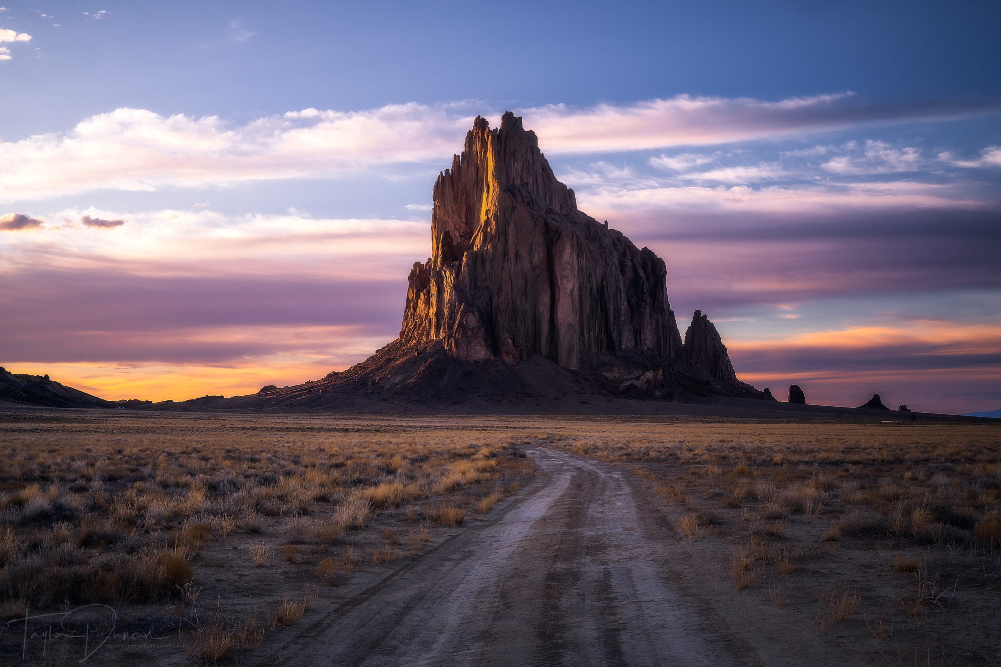
Watching the sunset at Shiprock is an incredible experience!
The Story
Like I said above, @spencerfochtman agreed to come with me to Shiprock. It was a 6 hour drive from White Sands, but it definitely felt like much more. There's not much in New Mexico except for open wilderness. We made two stops, the last of which in Gallup, which was only an hour out from the monument! Surprisingly enough, we were able to see Shiprock shortly after we left Gallup. It was incredible! The land was so flat that we could see it at least 40 miles out. We could also see other rock formations here and there, but our eyes were set on Shiprock.
About 40 minutes later, we arrived at the dirt road to take us closer to the rock. We were finally getting a sense of the scale of the rock. It was gigantic. The rock is the remnant of the throat of a volcano that formed 27 million years ago, about 3000 feet underneath the original surface. What we see today is the result of erosion over millions and millions of years - pretty incredible!
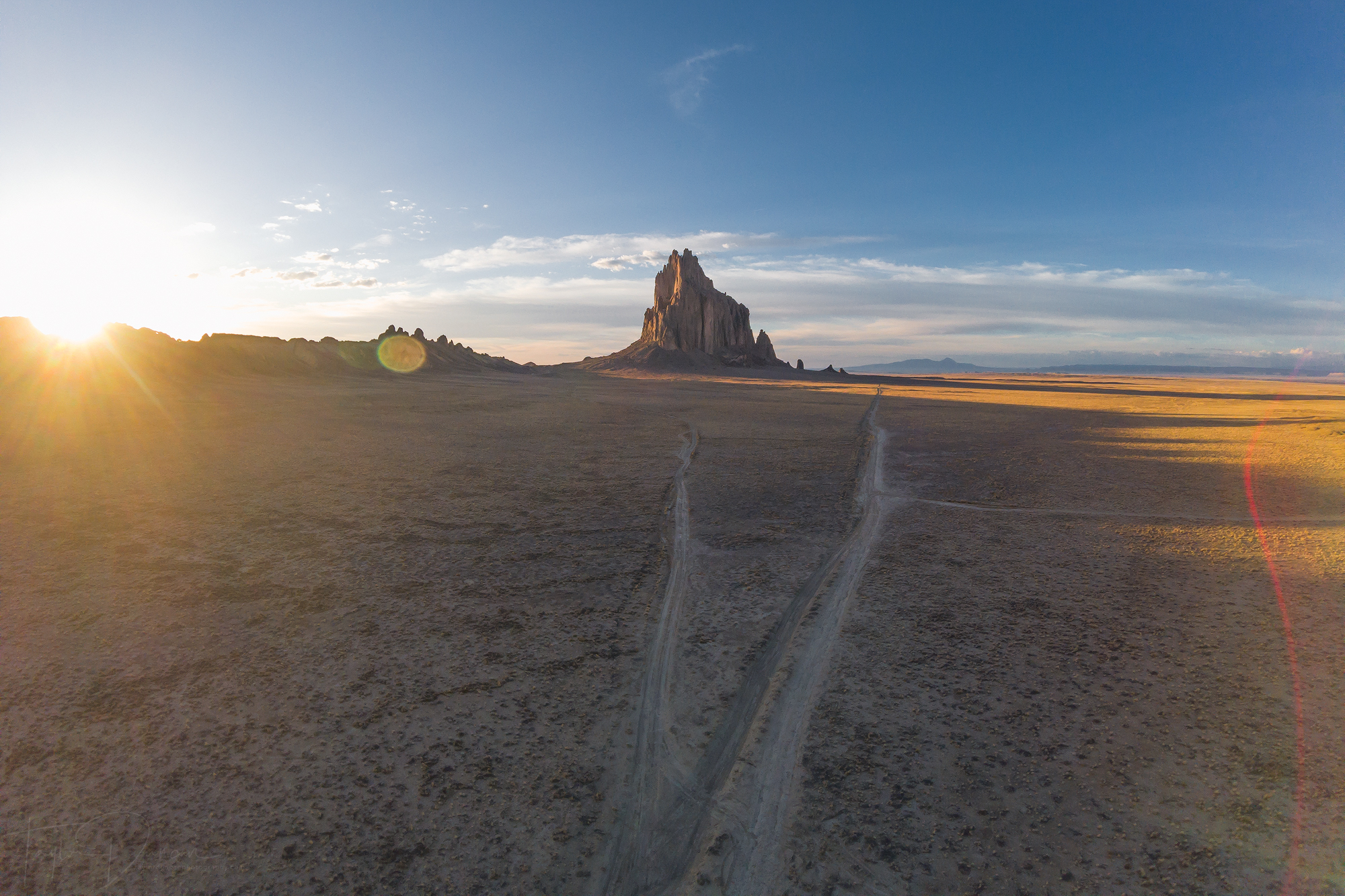
This drone shot shows the split in the dirt road where we set up!
We drove towards the rock on an unpaved, rocky road - definitely an off-roading experience - and found a spot where the road split. The aerial photo to the right depicts the split in the road. We found this to be the spot to get out and shoot! The road to the left was the perfect leading line to Shiprock as the sun started to set. I grabbed my tripod and got out into the middle of the road to start shooting. I knew this was the shot I wanted, so I basically stayed in one spot for my entire shoot.
I couldn't have asked for a better sunset. The clouds behind the rock lit up perfectly as the sun set (see the photo above "The Story"). Then they us blew up all around us with color and light. It was like we were watching someone paint the sky. We saw new areas of light every minute!
As the sunset started to fade, we discussed sleeping arrangements for the night. We decided it wasn't the best idea to camp out there since we were on Navajo land. As we ate our Mountain House dinners, I snagged us a room in Farmington, about 45 minutes away. Then, we waited for the stars.
It was nearly a full moon that night, so the stars weren't as bright as they could have been. They were still beautiful above Shiprock. @spencerfochtman got out his super bright flashlight again, and we started to shoot - I was the model this time! I walked down the road a little ways and shined the light to the sky as @spencerfochtman hit the shutter buttons. The photos were so surreal with the moon illuminating EVERYTHING with the stars above. It was the perfect finale to my New Mexico adventure!
We packed up our gear and navigated the road (which is much more challenging at night) and headed to Farmington. We arrived around 10 pm, and I had to get to sleep right away to have enough energy for my 12 hour drive out to California the next day!
Alabama Hills, California
Where are they?
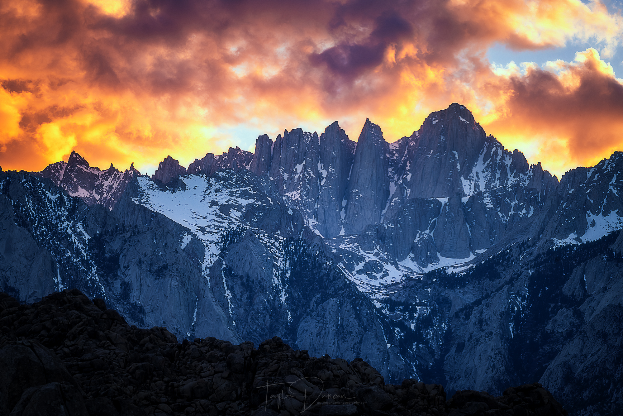
The sky put on a show above Lone Pine Peak & Mt. Whitney during sunset in the Alabama Hills.
The Story
This story really starts with my 12 hour drive to the Alabama Hills. It took me through northern Arizona, southern Utah, southern Nevada, and through Death Valley National Park. I felt so bad on many parts of this drive, because I was missing so many places just off my route that I've been wanting to photograph either for the first time or to re-photograph! These places include Canyon de Chelly National Monument, Monument Valley, Horseshoe Bend, Antelope Canyon, and Vermillion Cliffs National Monument. These are all the more reason to head back to the Southwest again very soon! All in all though, the drive had lots of very boring flat areas, which good music and audiobooks definitely helped me through!
I drove through Las Vegas and did not find very good drivers, as was the case the second time I drove through! Once safely through the city, it was back to the wilderness over mountain passes on either side of Death Valley National Park and finally to Lone Pine and the Alabama Hills! The eastern California scenery is some of the craziest that I've ever seen. I didn't exactly know what to expect, but in the span of an hour of driving, I was in the lowest point in North America and by the time I got to the Alabama Hills, I was staring at the highest point in the lower 48 - Mt. Whitney at 14,505 ft and the pride of the Eastern Sierra-Nevada mountain range.
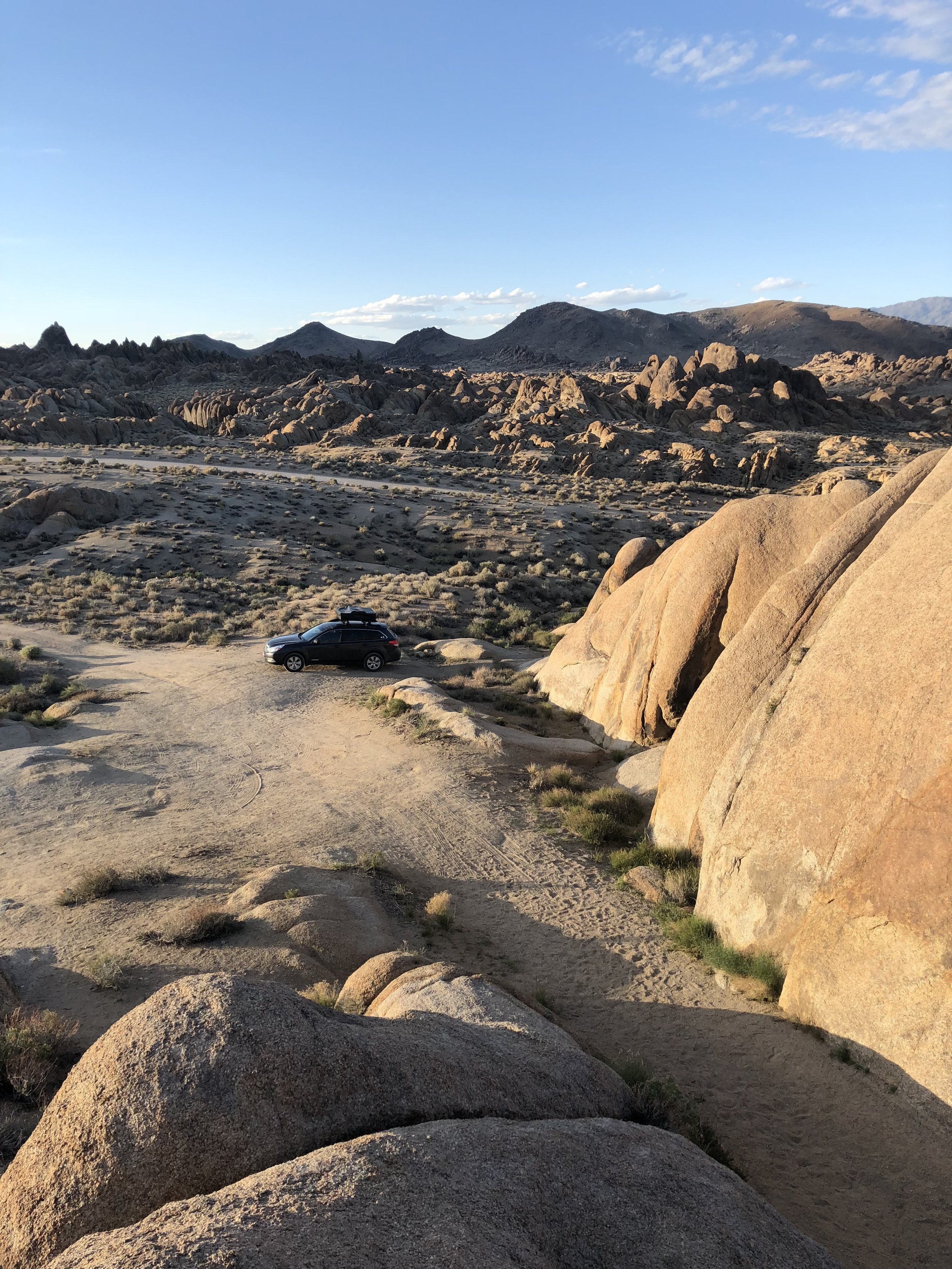
The Alabama Hills are on BLM land, so the camping is free! I found a nice spot next to the Mobius Arch trailhead, which I would hike the next morning. It was so good to get out of the car and just chill for few minutes before sunset. The site gave me a clear view of Mt. Whitney and Lone Pine peak and was a perfect spot to photograph the sunset. All I had to do was get my gear, walk about 20 yards into the brush and start shooting!
As you can see, the sky above the mountains BLEW UP with color. This trip spoiled me with amazing sunsets and sunrises. I mean... WOW. I shot it for a good 30 minutes before the light faded in awe the whole time. Even though there were lots of occupied campsites, they were so spread out that I felt like I was the only one in the area taking it in, which was one special feeling!
Once the color faded, I went back to my car for a quick ramen dinner. The stars and the moon were starting to come out. I hoped for more stars, but the moon was so bright that it washed out most of them. I still tried to get some star shots and am pretty happy with what I got despite the conditions. There were a few clusters of brighter stars above Mt. Whitney that came out very well. I didn't shoot for too long though, because the stars were moving out of sight behind the mountain and because I planned to wake up early for sunrise the next morning. I had my rooftop tent all set up, crawled in, and got some great sleep before the early 5 am alarm!
I woke to completely clear skies. I got organized, grabbed my gear, and walked across the road to the Mobius Arch trailhead, a very short trail - only 0.3 miles trail to the arch. The hike seemed longer, but maybe I was just excited and anxious to get to the arch. I got there and was amazed by this little arch. Looking through you can see Lone Pine Peak and Mt. Whitney. They look so small even though they're massive peaks!
There was a couple I met there - Dylan & Ashley - who had gotten there a few minutes before me. We quickly got to talking about how beautiful it was as the sun started to illuminate the peaks. After I took some shots, I asked Ashley if she would like model for some photos, and she kindly agreed. Dylan and I took some photos and she seemed VERY happy with the results! We said our goodbyes a few minutes later, and I shot for maybe 10 minutes more before heading back to my car. I ate some oatmeal breakfast and got organized for the next spot on my trip - Death Valley National Park.
Death Valley National Park, California
Where is it?

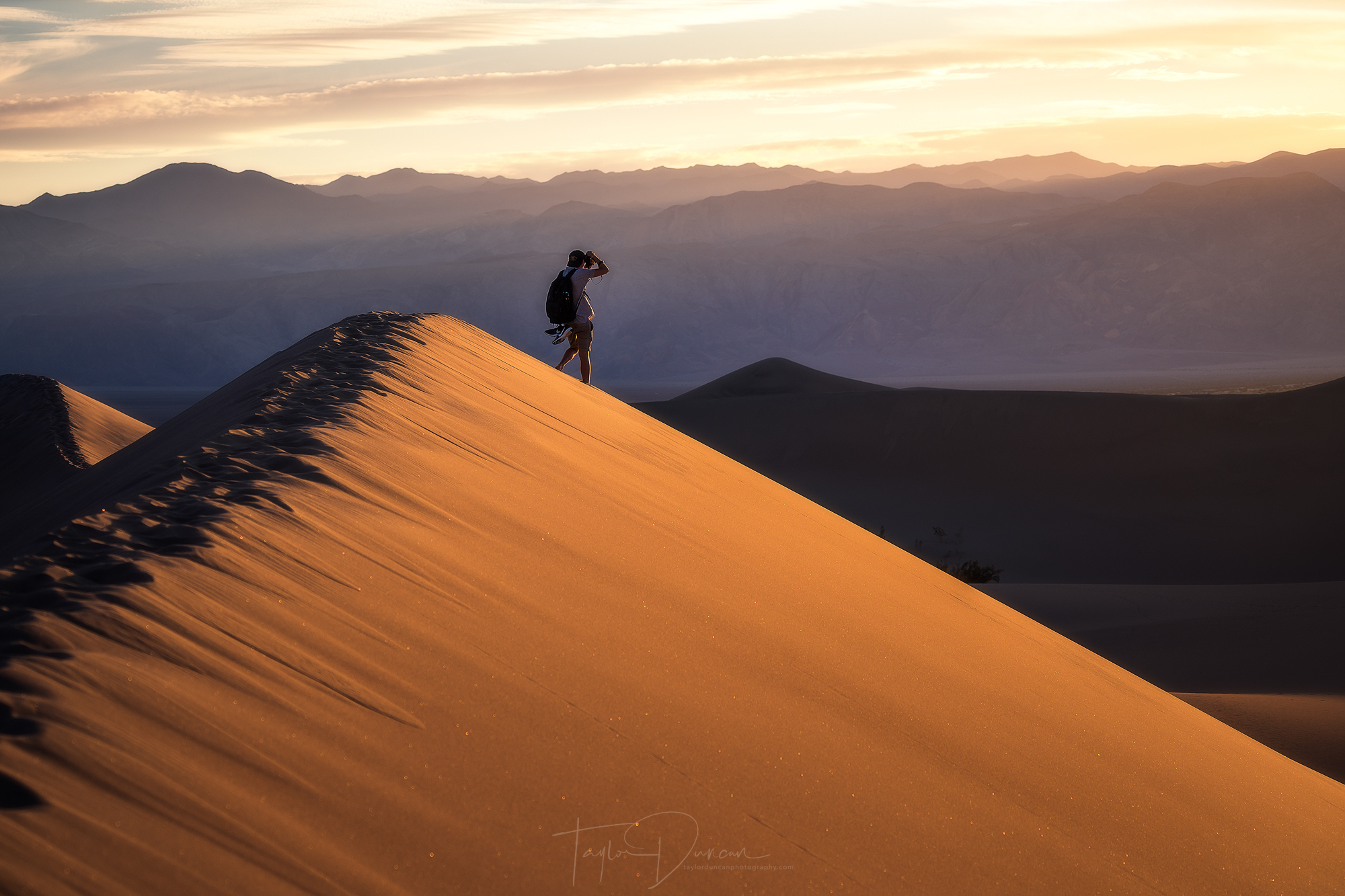
@cameronrosin made a great model after only meeting him a few minutes before this
The Story
Have you ever been above a flying fighter jet while driving your car? I'll let you think about that for a second before I begin my story... Well, that's where my Death Valley story starts. I had left Lone Pine in the mid-morning for the short hour and a half drive to my hotel in Death Valley and was coming over the first of two mountain passes. I had entered the western edge of the park and started my descent down the pass when I looked out at the scenery and something below me caught my eye. There, flying at God knows what speed just above the mountain ridge was a fighter jet. It flew into the valley and after a few minutes I lost sight of it, but was absolutely amazed by what I had just saw. I did not know this at the time, but further research revealed that Rainbow Canyon or Star Wars Canyon (named by Star Wars fans) is a popular training site for US and foreign military - pretty cool huh?
Aside from that newfound attraction, Death Valley is a massive park. It is the largest U.S national park not in the contiguous United States. The only problem was that I only had one day. There were so many places I wanted to see and take the time to photograph. So, I used the experience as a scouting expedition, getting as much information as I could while I was there. There were two places that I HAD to visit for the sake of being a tourist - Badwater Basin (the lowest point in North America - 282 feet below sea level) and Artist's Palette.
It was HOT - 102 degrees to be exact. The day before I left on the trip, it was 25 degrees in Wisconsin, so you could say that I wasn't used to the heat. Even though I didn't want anything to do with the outdoors until later, I hiked out into Badwater Basin and took in my surroundings. From there, I could see the highest point in the park - Telescope Peak at 11,043 feet, which was just incredible considering I was 282 feet below sea level! Did I mention that it was hot?

I then took the 5 mile single lane road to Artist's Palette, which is yet another geological wonder that I can't even pretend to understand. In the middle of the day, the colors were a little washed out, but you could still see the blues, purples, reds, and greens in the mountain side. This is one of the locations I'd like to further shoot the next time I head out to Death Valley at a different time of day, as it was beautiful!
After dinner, I got organized for my only photo shoot in Death Valley - sunset at the Mesquite Flat Sand Dunes. The parking lot was only five minutes from my hotel, so they were easily accessible. At this point in the day, about an hour and a half before sunset, it had cooled to a 'pleasant' 95 degrees. This wasn't ideal for hiking, but I stocked up on water and trudged my way into the dunes.
@cameronrosin getting the sunset shot in the Mesquite Flat Dunes
Shortly into my hike out, I met @cameronrosin. He was another photographer also on a road trip, so we hit things off right away. Hiking up and down dunes, we acted as models for the other as we went. The shot of him to the right, before the sun went down, is one of my favorites from the trip! We had ventured out just short of the highest dune and set up shop for sunset. I was debating on what composition I wanted and finally picked one out right before the clouds started lighting up.
The dunes are incredible after the sun goes down!
I knew I wanted to get a shot of the largest dune right in front of me, but it was away from the sunset. There were a few clouds above it, so I set up and just waited, hoping something would happen. Sure enough, no more than 10 minutes later, the clouds lit up, and I was treated to yet another beautiful sunset. I started to shoot, and because I had service, I started a live Instagram story to show off what I was looking at. I'll admit, since it was my first time doing it, I had no idea how to make it interesting for the duration of the sunset, but I like to think that followers enjoyed it! As I was shooting, @cameronrosin headed out of the dunes, and I was left all alone watching the sunset unfold.
I could not have asked for a better first photography experience in Death Valley, and it made me want to stay longer. However, I was on a schedule, so I got to sleep that night and woke up early to head back to Vegas to pick up my travel companion for the last portion of my trip - Escalante, Utah
Escalante, Utah
Where is it?

The finale of my trip at Jacob Hamblin Arch
The Story
This is one long story, since Escalante was the longest portion of my trip... so here we go!
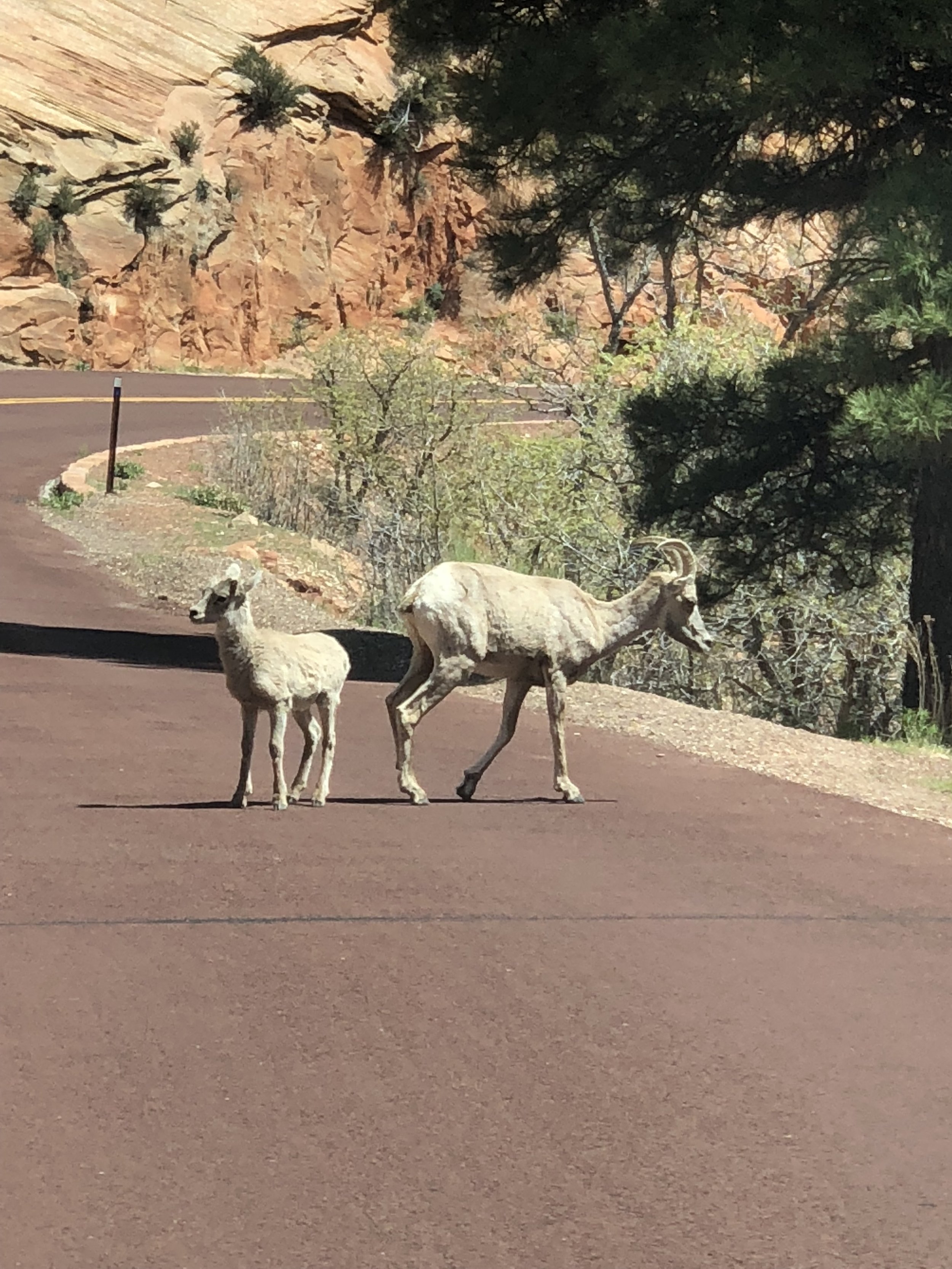
We found some mountain goats driving through Zion!
I picked up my friend Ben from the Las Vegas airport around 9am, and we began our adventure to Escalante! The fastest drive would have taken us around Zion National Park. Zion was only 30 minutes out of the way, so we decided, why not drive through Zion! That is definitely another trip in itself, but it was amazing to drive through! We saw a lot of the popular attractions, and I took mental notes of just about everything I want to photograph in a future expedition there. We even got to see some of the local wildlife; some mountain goats crossed the road on the eastern side of the park. It was definitely a good welcome to Utah, and it made us optimistic about what else we would find while there!
We arrived in the small town of Escalante, grabbed some extra food for the next few days and checked into the Canyons Bed & Breakfast. If you ever make it to Escalante and have to stay in town for a night, I would highly recommend this place. The owners were extremely nice and the breakfast in the morning was fantastic! The room we got was also the perfect place to rest and relax before the next four days in the wilderness! After a good pizza dinner in town, we got to sleep early to be ready for our adventure ahead!
Part 1: Reflection Canyon
We started down Hole-In-The-Rock Road around 9:30am, ready for the next 60 miles of unpaved roads. After 2 hours of jaw-rattling bumps, we made it to the Reflection Canyon trailhead! This was someplace that I had wanted to visit for a LONG time, and I was finally doing it!
Now I have to tell you a little bit about our hike to warn you about it if you decide to visit Reflection Canyon. It is an 8.5 mile hike out - up and down little valleys that could turn into slot canyons if you're not careful. There isn't one true trail, so you have to keep finding a trail to follow. There are some tips for this. Ben had a Garmin Fenix GPS watch and had the trail loaded onto it, so we followed that. I also downloaded the AllTrails app and paid for the premium app. I was able to download the trail information from the trailhead and used the GPS in my phone to track our progress. We weren't about to get lost out in the Utah desert!
On another note, there is also NO WATER on the trail for you to fill up, so you have to pack in all of your own water. Ben and I carried five liters each, but went through three and a half liters each on the hike, one way. Luckily, there was another group who was able to spare 3 liters for us or else the return hike would have been hell! So... if you do this hike, TAKE MORE WATER THAN WE DID!! THANK YOU SO MUCH TO THE OTHER GROUP!!

Here is a visual of our campsite on a flat portion of the rock face!
Apart from both of those issues, the hike itself was very difficult. I still have blisters from the constant uneven rock and soft sand. We pushed though and limped to all the way to a place above flat areas that could be used as campsites. We looked at where the other group was and had no idea how to get down. It was basically a rock face that seemed to be too steep to go down. We yelled down to the other group and they told us to trust our boots! OHHH BOY. It took us at least 20 minutes to navigate down the rock wall, but we finally made it to a site. We then actually moved our tent over to another spot across the rock face as we didn't want to try to traverse that in the middle of the night if we got up for stars! Thank you again to the other group for allowing us to move next to you! It was finally time to relax and take some photos!
8.5 miles hiked in Escalante
The view kind of hits you right in the face. You walk over this rock face and there it is. It's even more amazing in person! There weren't many clouds in the sky for sunset, but the moon was right above the canyon, which created an incredible visual. I'm not usually a fan of shooting the moon straight on, but in this case, I was overjoyed that it was there! I think it's one of the most beautiful scenes that I've ever witnessed. I do tend to say that a lot, but in this case, it was so true. There was just a little bit of light from the sun remaining, so it created this beautiful contrast between night and day! It was so good that I almost forgot that sunrise might be even better! We got in our tent and called it an early night exhausted, but happy.
I woke the next morning to light filling the tent. I excitedly grabbed my gear and walked to the edge of the canyon. There were clouds all around us, and they beautifully started to light up as the sun continued to creep towards the horizon. I took my shots, but I was more interested in capturing the sunstar when the sun crested the canyon wall. What I captured may be in my top three favorite photos I've ever taken! It was a STUNNING scene. As quickly as the photo opportunity started, it ended just as fast as the sun fully came over the horizon. It was now time to pack up and start the long hike back to the car.
After another 8.5 miles of hiking, we made it back to the car. We flung off our gear, turned the car on, turned the A/C to high, and sat there chugging water for 25 minutes. We were exhausted and dehydrated, so debated whether or not to stick to our original plan - drive back down Hole-In-The-Rock Road and hike to Zebra Slot Canyon. After awhile we were starting to feel better and decided to go for it. We packed up our items and started the 52 mile drive back down the road to the Zebra Slot Canyon trailhead!
17 miles hiked in Escalante
Part 2: Zebra Slot Canyon
Putting the hiking boots back on was super painful. We had blisters on our toes, heels, and ankles... OWWW! We had to push though and we did just that. You kind of get used to the blister pain as you go, but the beginning of hikes with them sucked! We limped our way onto the trail, which seemed to be much easier and well defined (or so we thought).

My boot for scale for how narrow Zebra Slot got!
The trail turns into a flat, exposed, and sandy wash for the last mile to the canyon. After hiking 19 miles in the last two days, this was exhausting, but we kept going, making sure to keep hydrated as we went. Finally after three miles, we saw the entrance to the slot canyon! It was quite wide at the mouth, but it quickly narrowed to the point that we had to take our packs off, because they didn't fit! Luckily, we both have been climbing at the local Milwaukee climbing gym - Adventure Rock - for awhile now, so we navigated into the heart of the canyon with ease.
What we found were some of the most ridiculous designs in rock that I've ever seen. On top of that, the color of the canyon was beautiful with the glow of the afternoon sun radiating in from above.
For a brief period of time, we had the place all to ourselves! So of course we had to play around with some slot navigation photos while in there!
Unfortunately, after 15 minutes in here, a solo hiker and a small group of hikers came into the canyon as well. As you can see, this canyon is not wide enough to accommodate more than two or three people. So we grabbed our stuff, carefully went around the people coming into the canyon, and started the three mile hike back to the car.
It seemed a little easier heading back with our spirits high after what we had just seen. After we got back, we started the 35 mile drive back down the road to the Coyote Gulch trailhead for the next day's adventure!
23 miles hiked in Escalante
Part 3: Coyote Gulch
I have finally gotten to the finale of my trip! No, I don't consider the subsequent 23 hours of driving home to be the finale, since much of that was absolutely horrible! The build up to the Coyote Gulch hike was interesting, as my girlfriend Anna had flown into Salt Lake City that morning and met up with my friend Chris to drive down to meet up with Ben and I. The only issue was that there were three more of Chris's friends - Morgan, Derek, and Jen - who were coming as well, and they had to finish their work days. Ben and I had gotten to the Coyote Gulch trailhead around 7:30pm and set up our camp stuff for the night. After more Mountain House dinners, we called it a night around 9pm. Our friends from Salt Lake City left around 5pm, but with traffic, the 5.5 hour drive down to the trailhead turned into a 7 hour marathon drive, and they didn't make it to the trailhead until midnight! It was great seeing them when they woke us up (especially Anna as we hadn't seen each other in a week), but sleep was a definite priority as we had a eight mile hike to do the next day!

The crew at the entrance to Coyote Gulch
We woke as the sun rose, ate a Mountain House breakfast, drove a car to the exit of the trailhead (so we didn't have an extra 2 miles to do the next day), and started our hike towards Coyote Gulch. It is about 2 miles to the first feature of the hike and the entrance to the Gulch. I think this feature was one of my favorite experiences of the entire trip - Crack-In-The-Wall.
Anna looks to the sky in the Crack-In-The-Wall
This is where a slab of a cliff face broke away from the cliff leaving an area no wider than two feet to navigate through. Hikers have to lower their packs down the cliff by rope in order to get through or else they won't fit! Once all of our packs got lowered, we navigated through the two cracks. I tried a little photoshoot with Anna in the first crack, but I found the designs in the second crack to be absolutely incredible! We spent 10 minutes here before having to move on due to more hikers trying to get through. I could have spent half the day in there, but we had to hike on!
We then hiked our way down into the Gulch. It is a deep canyon with a stream that meets up with the Escalante River just past where we entered the canyon. It was starting to get warm, but once we reached the canyon floor, THERE WAS THE STREAM! We were all happy to see it, but especially Ben and I as we had been exposed to the elements without any natural sources of water for two and a half days! It was so nice to take the boots off and soak our feet for awhile! After a reapplication of sunscreen, we continued on our hike - six miles to go until our camp spot next to Jacob Hamblin Arch!
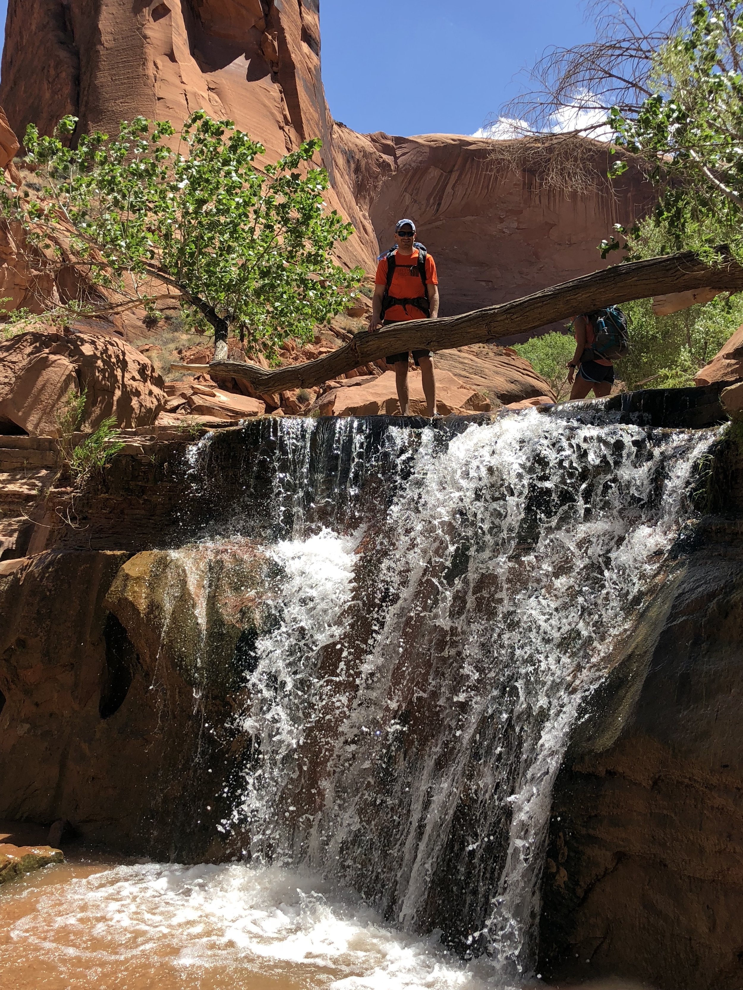
One of the many small waterfalls we encountered with Ben for scale
The seven of us meandered through the stream in our sandals for hours admiring the massive canyon walls and the intricate details at their base next to the stream. We ate lunch in a rounded out overhang at the base of the canyon wall while our feet took a break just a few feet from the stream. The lunch menu included PB&J sandwiches and summer sausage and they tasted oh so good! As the trail continued, we discovered many little waterfalls, which always added a little drama to the hike as they were difficult to get past. There was one that took us at least 15 minutes to figure out with bumps and bruises to prove it! We were always excited to see them however, because of how they broke up the monotony of the meandering stream.
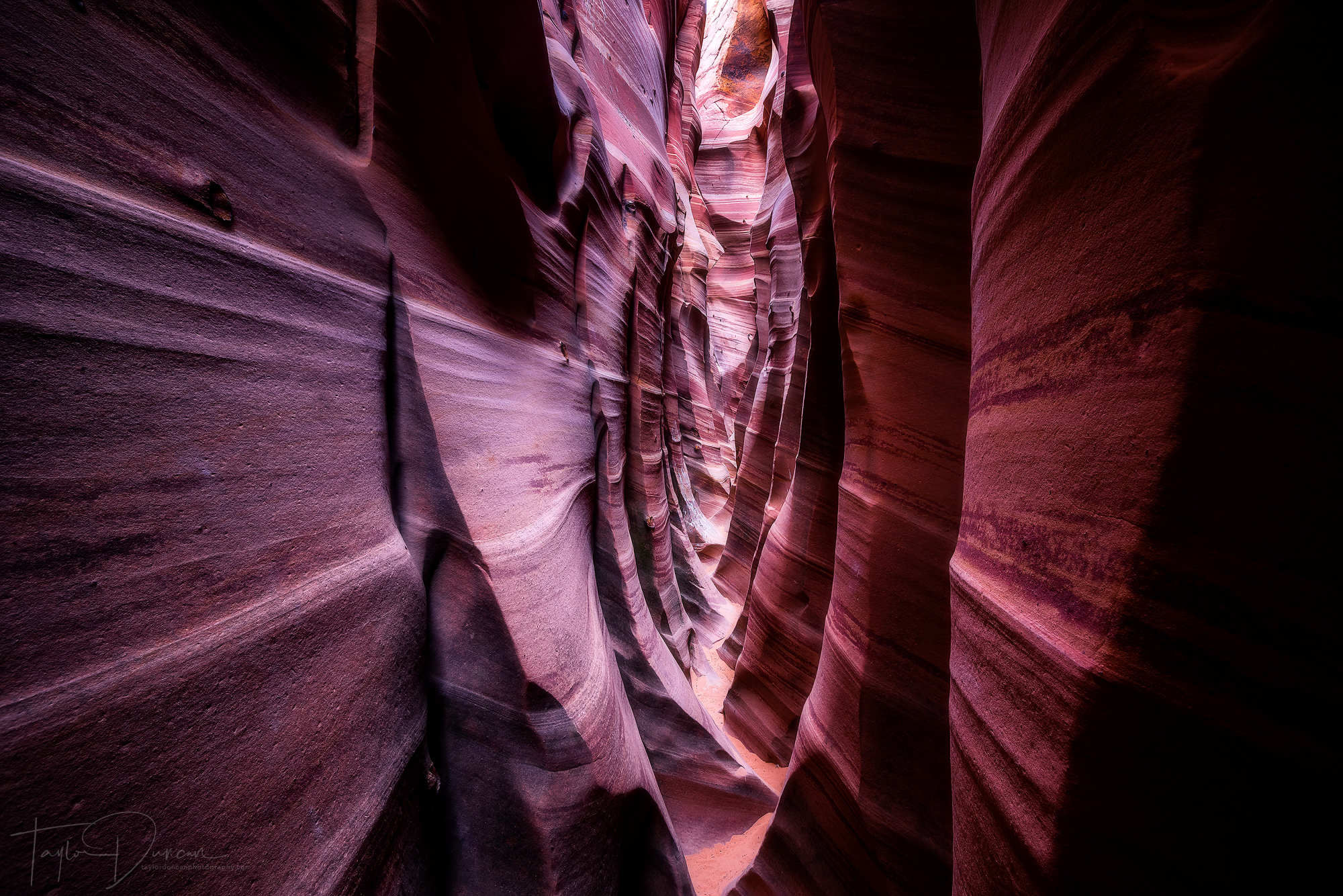
We then came to a portion of the trail where the water formed little slots above another small waterfall. These slots were so beautifully colored with the red, yellow, and orange Southern Utah rock along with purples and greens from the moss that had formed. This was one of the features I had to shoot, as I had never seen anything like it! There were four or five of them, but I found the one to the left to be the most beautiful and interesting. The slot in the rock is no more than five inches wide!
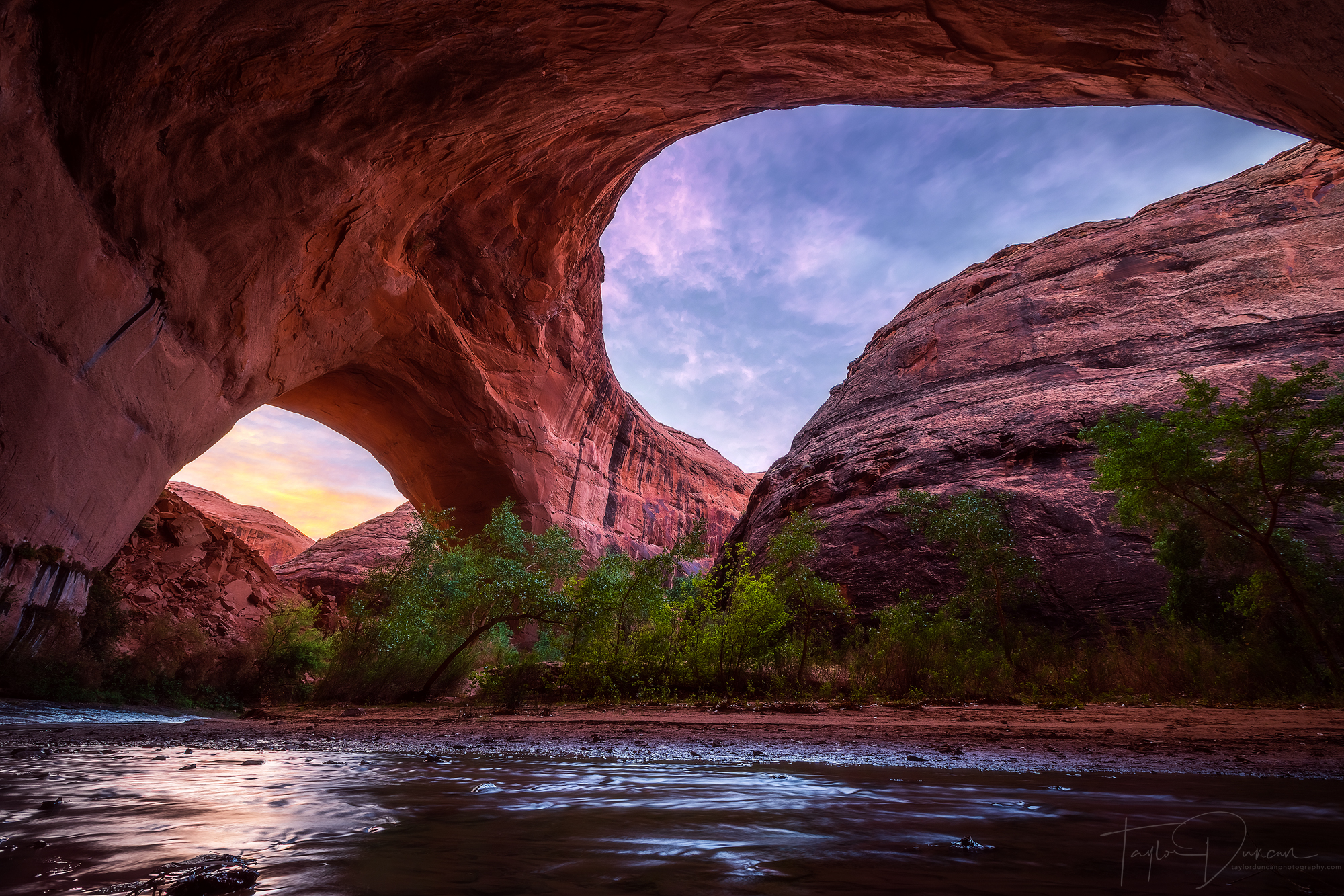
Shortly after we encountered the slots, we finally made it to Jacob Hamblin Arch! It took us most of the day, but we made it! We had to hike around it to where we would set up camp, but I was a little confused. At first I didn't think it was the correct arch as all of the photos I had seen made it seem like it was two connected arches above a stream.

Upon further investigation, I found that we were indeed in the right spot, but the second arch was actually just an overhang on the canyon wall. It was pretty incredible to see in person. You can see it in this photo left of the protruding rock from the top of the canyon wall the next morning. The arch itself is located in that protruding rock. Pretty cool huh??
31 miles hiked in Escalante
That night, we got our camp set up, ate Mountain Houses and a fine noodle dinner, and played cards until sunset. Earlier that day, the head to my tripod came off, and I could not get it back on! I had to borrow Morgan's Gorillapod for my sunset shoot, which proved to be extremely difficult to set up. Those aren't necessarily made for sturdy setups on the ground! It took me a bit, but I figured it out and got my shots in. There weren't any clouds so the shots were somewhat basic. Thinking I had my shots for the rest of my trip, I gave the tripod back to Morgan, and we headed to sleep. I would have gotten up for stars, but the moon was so bright that it was pointless. The moon did make for a nice show in the canyon though - an experience I won't forget!
Sunrise at Jacob Hamblin Arch
We had to leave early the next morning so Anna and I could get out of the canyon and to Denver in at a reasonable time. When I woke up to wispy clouds in the sky before sunrise, I jumped out of bed and woke Morgan to get the Gorillapod again. I ran across the stream and got set up just in time! The sunrise display was gorgeous! This became the perfect finale to the trip. Southwest USA, you wowed me yet again! I can't wait to get back to you soon!

After the sunrise, we hastily packed up and began the two mile trek back to the car. In order to do that though, we had to scale the canyon wall. Someone had left a sturdy rope attached to the wall so that helped immensely. If it weren't there, one of us would have had to free-solo the wall and fix a rope for the rest of us! One by one all seven of us scrambled up the canyon and made it safely. It was a challenge hiking straight up about 100 feet, but we made it.

The rest of the hike was challenging climbing up the slickrock, but we made it in good time. At one point during a quick break, the group looked so epic that I had to take a shot. It was definitely a shot that could be used on a band's album cover!
Once we got back to the parking lot, I re-packed my car, now with Anna's stuff. With hugs, we said our goodbyes. Ben went with Chris & crew to explore a few more canyons in Escalante, before he had a flight home out of Salt Lake City later that night.
33 miles hiked in Escalante
Meanwhile, Anna and I drove to Denver through the beautiful Utah badlands and the Colorado Rocky Mountains. By the time we got there, we were so exhausted. We had a quick dinner with Denver friends before passing out at our hotel. The next day we braved 40mph crosswinds in Nebraska and Iowa and safely got home to Milwaukee after a 15 hour drive. It seems that the weather through the plains states always punishes me, but if that's the punishment for one epic trip, then it's WORTH IT!
My Gear
Camera, Lenses, & Tripod: Sony Alpha A7RIII -- Sony F/2.8 24-70mm -- Canon F/2.8 16-35mm -- Canon F/4.5-5.6 100-400mm -- Canon F/1.8 50mm -- Metabones EF Adapter -- Induro GTT204M2 Stealth Tripod
Backpacks: F-Stop Tilopa (Orange) -- Gregory Baltoro 65 Pack
Hiking Boots: KEEN Targhee III Mid WP
Tents: REI Half Dome 3 Plus -- Yakima SkyRise 2 Rooftop Tent
THANK YOU
Here's a big thank you to Dani, Scotty, Spencer, Dylan, Ashley, Cameron, Ben, Anna, Chris, Morgan, Derek, and Jen for helping make this trip an incredible experience and one that I won't ever forget!
